
The Tour du Mont Blanc was first marked between 1950 and 1952, making it the first truly international GR®. Indeed, it was in 1947 that the Comité National des Sentiers de Grande Randonnée (CNSGR) was born. Three years later, the CNSGR Savoie, led by Marc de Seyssel, gave birth to the first route of the TMB between three cross-border regions in France, Italy and Switzerland.
Since then, the Tour du Mont Blanc has undergone several changes and has been expanded with many variants. At present, the official route covers a distance of 160 to 170 kilometres and 10,000 metres of ascent.
To enable hikers and trekkers to find their way around the trails, the signposting of the Tour du Mont Blanc has been the subject of particular attention since its creation. It is also regularly maintained by the signposters of the three countries that the route crosses.
How are the trails of the Tour du Mont Blanc marked? What to use during your trek around the highest summit in Western Europe?
In this article, find out how to orient yourself on the trails and learn how to recognize the Tour du Mont Blanc markings in France, Italy and Switzerland! 🙂
How to find your way around the TMB?
The official topo-guide of the Tour du Mont-Blanc
On the TMB hiking trails, the markers are clear and numerous, allowing you to easily find your way.
However, don’t go off half-cocked without any other way of visualizing your route!
Before setting off, get hold of the official Tour du Mont-Blanc topo-guide from the French Hiking Federation. The main route of the classic Tour du Mont Blanc and several variants are described in great detail and the 1:30,000 scale maps will allow you to easily find your route for the day.
In addition, it contains a lot of useful information for your stay in the Mont Blanc region: walking times, altitudes, public transport, accommodation, mountain refuges, campsites, grocery stores, train stations, etc
You can find it in most bookstores that have a section dedicated to hiking, in sports stores (Decathlon, Au Vieux Campeur, Chullanka, etc.) and on the FFR website.
Which topographic maps to prepare the Tour du Mont Blanc?
Several hiking maps allow you to easily find your way on the hiking trails of the Tour du Mont Blanc.
The first one is the official IGN map of the Tour du Mont Blanc. At a scale of 1:50000, this map allows you to find your way around the entire TMB route.
If you wish to have more precise maps, you will have to get the two following IGN TOP 25 maps:
- Map 3630 OT – Chamonix, Mont Blanc Massif
- map 3531 ET- Saint-Gervais-les-Bains, Massif du Mont Blanc
As the name suggests, these maps are at a scale of 1:25000, which will give you a more accurate view of your route.
Finally, if you wish to make a customised Tour du Mont-Blanc itinerary of several days (by doing it partially or by taking the Haute-Route, for example), you can make your own map with the IGN’s customised map service.
Cross-border cooperation for guidance
Throughout your Tour du Mont Blanc, you will be able to easily find your way around the main route thanks to the signposts that line it. Usually placed at crossroads, these vertical signs provide information on where you are, where you are going next and how long it will take to get there.
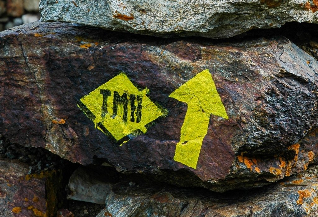
In all three countries, you will also find a common logo that will allow you to identify the route of the Tour du Mont Blanc: the inscription “TMB” and an arrow marked in black in a green square.
However, apart from this logo, the markings may vary from country to country.
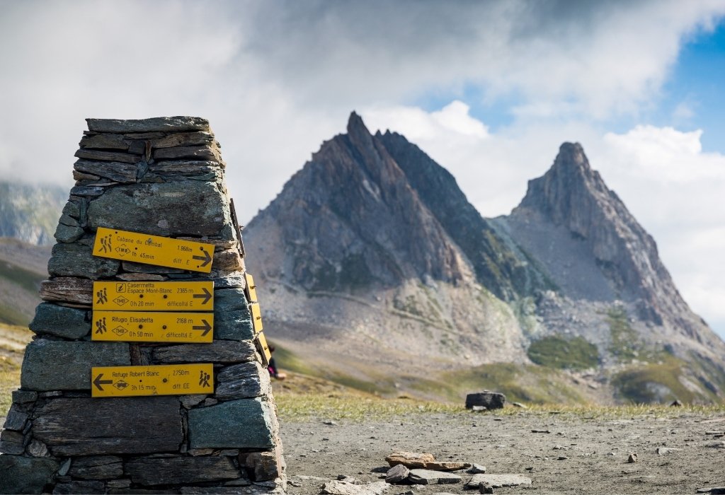
The Tour du Mont Blanc markers country by country
In France, Italy and Switzerland, the TMB route is indicated by markers placed on trees, rocks, poles, walls and different elements of the landscape. This marking is different in the three countries crossed by the TMB.
The Tour du Mont Blanc markers in France
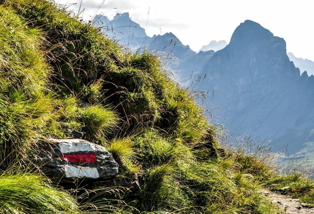
In France, the paths of the Tour du Mont Blanc GR are indicated by a white and a red line. When they are parallel, continue straight ahead. At intersections, they form an arrow to the left or right. Finally, if the white line and the red line form a cross, it means that it is not in this direction that you should go.
You will also be able to see the markings of the Grande Randonnée de Pays (GRP) trails, a yellow and red line, as well as those of the Petite Randonnée (PR) trails, a yellow line.
The Tour du Mont Blanc markers in Italy
The markings of the Tour du Mont Blanc in Italy are indicated by yellow marks. They can be lines, arrows, circles, triangles or a diamond with a black border in which “TMB” is written.
Moreover, in Italy, on the signposts, you will see different letters indicating the difficulty of the hiking route:
- T: marked walking trails, easy walks and hikes.
- E: marked hiking trails with no particular technical difficulties.
- EE: marked hiking trails that may have difficulties such as slippery slopes, late snow, occasional scree, or the need to put your hands down, for example.
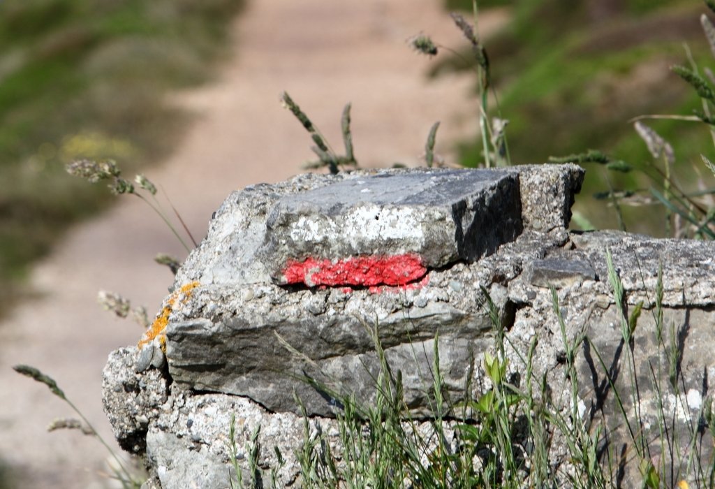
The Tour du Mont Blanc signposting in Switzerland
In Switzerland, you can find two types of markings on the TMB course. They can be colour coded on the signposts or marked on rocks, trees, etc.
The yellow markers indicate hiking trails with no technical difficulties.
The white-red-white markers indicate mountain hiking routes that may include exposed or technical sections.
You are now ready to hike the trails of the Tour du Mont Blanc without fear of getting lost! 🙂


0 Comments